| ||||||||||||
| ||||||||||||
A joint service of the UK Ag Weather Center and the National Weather Service.
Click here for UKAWC Point Agricultural, Lawn & Garden Forecast/Outlook in case of corrupt tables. Regional Hourly Observations For County Issued at 1000 AM EDT FRI MAR 14 2025 NORTH GEORGIA CITY SKY/WX TMP DP RH WIND PRES REMARKS ATLANTA PTSUNNY 60 56 86 SE3 30.00R TC 16 ATHENS CLOUDY 53 52 96 CALM 30.01R FOG TC 12 CHAMBLEE PTSUNNY 60 55 83 CALM 30.00R TC 16 PEACHTREE CITY FOG 57 57 100 CALM 30.01R VSB 1/2 TC 14 ROME CLOUDY 57 53 86 CALM 29.98R TC 14 WEST ATLANTA PTSUNNY 62 55 77 CALM 30.00R TC 17 GAINESVILLE SUNNY 60 51 72 SE7 30.03R TC 16 CARTERSVILLE N/A 59 55 88 E3 30.00R TC 15 CITY SKY/WX TMP DP RH WIND PRES REMARKS DALTON* PTSUNNY 61 57 86 SE3 29.97R TC 16 LAWRENCEVILLE* CLOUDY 57 57 100 E5 30.02R FOG TC 14 MARIETTA PTSUNNY 63 55 76 SE3 29.98R TC 17 KENNESAW* PTSUNNY 61 55 81 VRB3 30.01R TC 16 CANTON* PTSUNNY 58 52 79 E6 30.02R TC 15 BLAIRSVILLE* PTSUNNY 51 48 89 CALM 30.02S TC 11
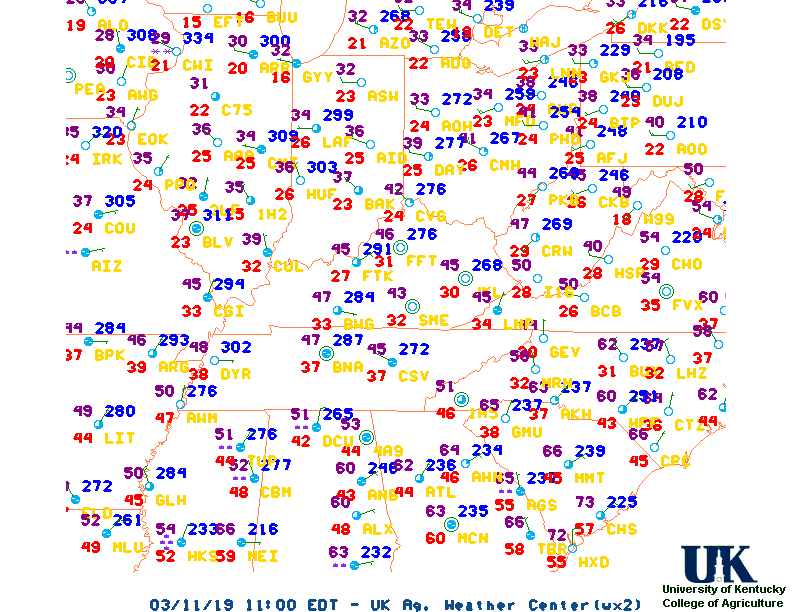
Current Agricultural Weather Conditions in Georgia Based on observations at 1000am EDT, Friday March 14, 2025 Across Georgia...temperatures are near 60 degrees north, near 58 degrees central, and near 64 degrees south. Current sky conditions are partly sunny north, fog central, and mostly sunny south. In the north, relative humidity is near 86%, and the dew point is near 56 degrees. In the central part of the state, relative humidity is near 100%, and the dew point is near 58 degrees. In the south, relative humidity is near 83%, and the dew point is near 59 degrees. Winds are from the southeast at 3 mph north, where conditions are favorable for spraying. Winds are from the southeast at 6 mph central, where conditions are not favorable for spraying due to fog. Winds are calm south, where conditions are favorable for spraying. Based on current available observations, the highest temperature is 67 degrees at Fort Stewart. The lowest temperature is 53 degrees at Athens.
Current NOWCAST not available: Nowcasts are not issued routinely during fair weather. Only when precipitation or other significant weather is occuring in this county will these forecasts be issued. Currently, there is no short term forecast in effect. Hazardous Weather Outlook For County,GA 546 AM EDT Fri Mar 14 2025 DAY ONE Today and TonightThunderstorms are possible for northwest Georgia late tonight and into early Saturday morning. A few thunderstorms could produce hail and damaging winds. DAYS TWO THROUGH SEVEN Saturday through Thursday An Enhanced Risk (Level 3 of 5) of severe weather is expected between Saturday afternoon and Sunday morning. All severe weather hazards including, tornadoes, damaging winds and hail are possible with this event. Minor flooding and flash flooding concerns could also develop in north Georgia Saturday night into Sunday morning. Please continue to monitor the forecast moving forwards. SPOTTER INFORMATION STATEMENT While spotter activation is not needed, spotters are encouraged to report or relay severe weather reports today and tomorrow. Please continue to keep an eye on Saturday into Sunday, as spotter activation may be requested during this time period.
7-Day Forecast For County, GA Issued at 332 AM EDT Fri Mar 14 2025 TODAY TONIGHT SATURDAY SATURDAY NIGHT SUNDAY SUNDAY NIGHT MONDAY MONDAY NIGHT TUESDAY TUESDAY NIGHT WEDNESDAY WEDNESDAY NIGHT THURSDAY
Medium & Long Range Outlook For Georgia
                              GEORGIA
                 ---------------------------------------------
                 6 TO 10 DAY  8 TO 14 DAY   30 DAY    90 DAY
                   MAR 19-23    MAR 21-27    JUN       JUN-AUG
                 -----------  -----------  --------  ---------
   Temperature:     Normal        Above
 Precipitation:      Above        Above

....  Medium and long range outlooks provided by NCEP/K. Thomas Priddy
Almanac Information Historical Weather And Climate Facts For Today MARCH 14TH HISTORIC WEATHER EVENTS ...1870... The term "blizzard" was first applied to a storm which produced heavy snow and high winds in Minnesota and Iowa. (David Ludlum) ...1944... A single storm brought a record 21.6 inches of snow to Salt Lake City UT. (The Weather Channel) ...1960... Northern Georgia was between snowstorms. Gainesville GA received 17 inches of snow during the month, and reported at least a trace of snow on the ground 22 days in March. Snow was on roofs in Hartwell GA from the 2nd to the 29th. (The Weather Channel)
Ag Weather Center, Department of Biosystems & Agricultural Engineering, University of Kentucky | ||||||||||||


![[2nd Source TWC]](http://maps.weather.com/images/maps/current/curwx_720x486.jpg)