| ||||||||||||
| ||||||||||||
A joint service of the UK Ag Weather Center and the National Weather Service.
Precision Agriculture Weather Forecast For CountyFor Your Farm PointAgCast...Click here. Regional Hourly Observations For County Issued at 400 PM CDT FRI MAR 14 2025 NORTHWEST IOWA CITY SKY/WX TMP DP RH WIND PRES REMARKS CHEROKEE CLOUDY 70 41 35 S22G32 29.01F TC 21 DENISON CLOUDY 64 41 42 SE10G18 29.02F TC 18 ESTHERVILLE CLOUDY 69 45 41 S25G33 29.06S TC 21 LE MARS PTSUNNY 72 41 33 SE14G23 28.97S TC 22 MAURICE CLOUDY 70 37 30 S16G22 28.98S TC 21 SHELDON CLOUDY 68 41 37 S9 29.00S TC 20 SIOUX CITY PTSUNNY 77 35 21 SE40G59 28.96F TC 25 SPENCER CLOUDY 69 42 37 SE22G35 29.04F TC 21 STORM LAKE CLOUDY 66 43 42 SE30G38 29.03F TC 19
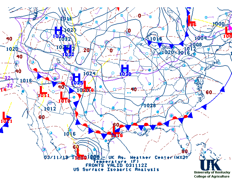
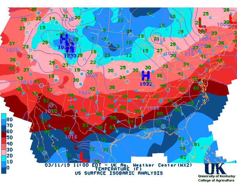
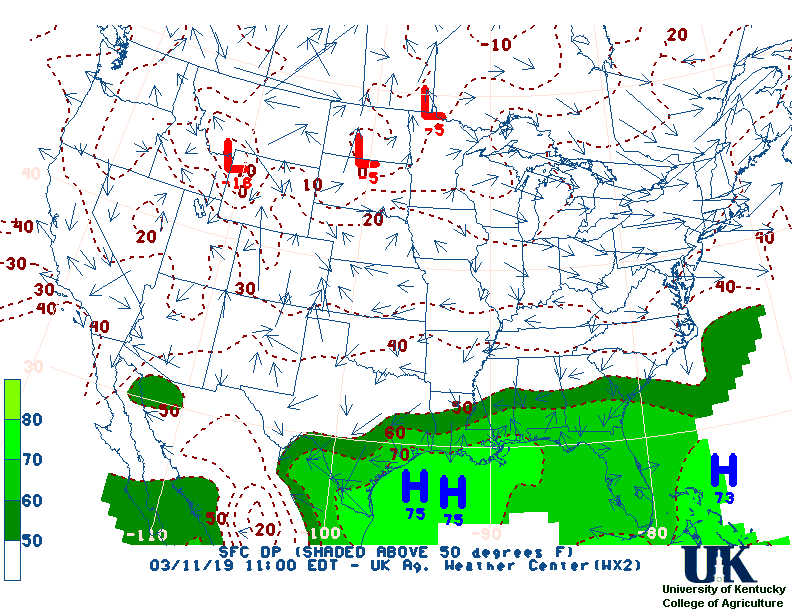
Current Agricultural Weather Conditions in Iowa Based on observations at 400pm CDT, Friday March 14, 2025 Across Iowa...temperatures are near 77 degrees west, near 79 degrees central, and near 82 degrees east. Current sky conditions are cloudy west, cloudy central, and cloudy east. In the west, relative humidity is near 21%, and the dew point is near 35 degrees. In the central part of the state, relative humidity is near 27%, and the dew point is near 43 degrees. In the east, relative humidity is near 28%, and the dew point is near 46 degrees. The heat index is near 80 degrees east. Winds are from the southeast at 40 mph with gusts at 59 mph west, where conditions are not favorable for spraying due to strong winds. Winds are from the southeast at 23 mph with gusts at 35 mph central, where conditions are not favorable for spraying due to strong winds. Winds are from the southeast at 24 mph with gusts at 33 mph east, where conditions are not favorable for spraying due to strong winds. Based on current available observations, the highest temperature is 83 degrees at Iowa City. The lowest temperature is 66 degrees at Storm Lake.
Current NOWCAST not available: Nowcasts are not issued routinely during fair weather. Only when precipitation or other significant weather is occuring in this county will these forecasts be issued. Currently, there is no short term forecast in effect. Hazardous Weather Outlook For County,IA 532 AM CDT Fri Mar 14 2025 DAY ONE Today and tonight. Warm and dry air along with gusty south winds will result in elevated fire weather conditions Friday. Use extreme caution if burning. A large and complex storm system impacts the region later today through Saturday. This system brings multiple risks to the area, beginning with scattered thunderstorms late this afternoon into the evening. A few strong to severe storm damaging wind gusts to 70 mph and large hail to quarter size are possible from the Interstate 29 corridor and eastward, with the greater threat in portions of northwest Iowa and southwest Minnesota. Winds increase tonight west of I-29. Rain transitions to snow west of I-29 through the overnight hours, with a period of mixed precipitation. DAYS TWO THROUGH SEVEN Saturday through Thursday. Transition to snow continues east along and east of I-29 after daybreak Saturday, with a brief period of mixed precipitation. Strong northwesterly winds will continue to gust between 45 and 60 mph, tapering down in the evening hours. Snow diminishes from west to east Saturday. Light snowfall accumulations are expected, although heavier totals of four inches or more are expected in a narrow band. Light ice accumulations are also expected. Travel Saturday will be hazardous due to snow and strong winds. Prepare to alter or cancel travel plans and check road conditions via 5-1-1 ahead of time. SPOTTER INFORMATION STATEMENT Spotter activation may be needed Friday afternoon and evening.
7-Day Forecast For County, IA 428 PM CDT Fri Mar 14 2025 TONIGHT SATURDAY SATURDAY NIGHT SUNDAY SUNDAY NIGHT MONDAY MONDAY NIGHT TUESDAY TUESDAY NIGHT WEDNESDAY WEDNESDAY NIGHT THURSDAY THURSDAY NIGHT FRIDAY
Medium & Long Range Outlook For Iowa
                                 IOWA
                 ---------------------------------------------
                 6 TO 10 DAY  8 TO 14 DAY   30 DAY    90 DAY
                   MAR 20-24    MAR 22-28    JUN       JUN-AUG
                 -----------  -----------  --------  ---------
   Temperature:      Above        Above
 Precipitation:     Normal       Normal

....  Medium and long range outlooks provided by NCEP/K. Thomas Priddy
Almanac Information Historical Weather And Climate Facts For Today MARCH 14TH HISTORIC WEATHER EVENTS ...1870... The term "blizzard" was first applied to a storm which produced heavy snow and high winds in Minnesota and Iowa. (David Ludlum) ...1944... A single storm brought a record 21.6 inches of snow to Salt Lake City UT. (The Weather Channel) ...1960... Northern Georgia was between snowstorms. Gainesville GA received 17 inches of snow during the month, and reported at least a trace of snow on the ground 22 days in March. Snow was on roofs in Hartwell GA from the 2nd to the 29th. (The Weather Channel)
Ag Weather Center, Department of Biosystems & Agricultural Engineering, University of Kentucky | ||||||||||||


![[2nd Source TWC]](http://maps.weather.com/images/maps/current/curwx_720x486.jpg)