Weather and Climate Synopsis
|
|
County, Illinois Weather and Climate Synopsis |

[National] [International] [Learning] [EWOCK] [Reg Clim Ctrs] |
(Click image to zoom) or
Click Here
Satellite images from NOAA
Also see NWS Watch/Warning Maps |
A joint service of the UK Ag Weather Center and the National Weather Service.
Synopsis...
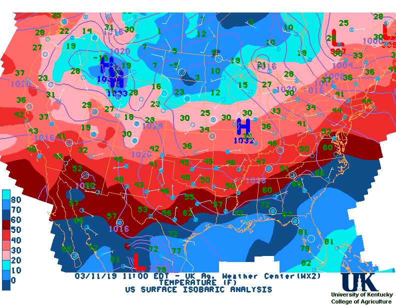
A SURFACE LOW PRESSURE SYSTEM WAS ACROSS THE NORTHERN GREAT LAKES AND PROVIDED MOSTLY CLOUDY SKIES OVERNIGHT AND INTO MONDAY MORNING. EARLY MORNING LOW TEMPERATURES RANGED MAINLY FROM 45 TO 50 DEGREES ACROSS THE REGION. COOLER TEMPERATURES WERE ACROSS ILLINOIS WITH MORNING. TEMPERATURES WERE SLOWLY CLIMBING INTO THE UPPER 40S ACROSS NORTH CENTRAL ILLINOIS. WITH SOME PATCHY SUN...TEMPERATURES CLIMBING INTO THE UPPER 50S ACROSS FAR SOUTHEAST ILLINOIS. SCATTERED LIGHT RAIN HAD DEVELOPED ACROSS PARTS OF NORTH CENTRAL ILLINOIS. AS LOW PRESSURE IS ACROSS THE NORTHERN GREAT LAKES TODAY...MOSTLY CLOUDY SKIES AND SCATTERED LIGHT RAIN CAN BE EXPECTED. HIGH TEMPERATURES WILL RANGE FROM THE LOWER 50S ACROSS NORTH CENTRAL ILLINOIS TO THE LOWER 60S ACROSS SOUTHEAST ILLINOIS. AS THE LOW PRESSURE MOVES NORTHEAST INTO SOUTHERN CANADA...EXPECT A DECREASE IN CLOUDS THIS EVENING AND OVERNIGHT ACROSS CENTRAL AND SOUTHEAST ILLINOIS. $$
NORTHWEST ILLINOIS

CITY           SKY/WX    TMP DP  RH WIND       PRES   REMARKS
MOLINE         SUNNY     61  49  64 S14G24    29.53F TC  16
STERLING*      SUNNY     58  49  72 SE8       29.59F TC  14
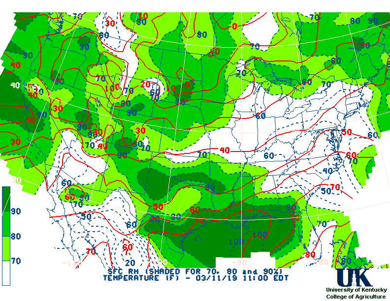
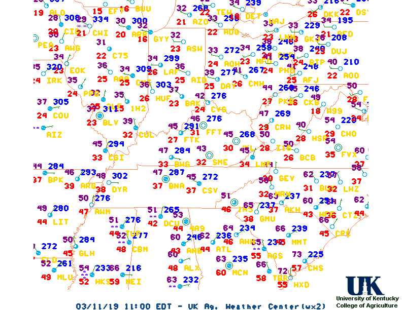
![]() Current Temperatures, Dewpoint Map, RH, Wind, Regional Obs, Surface 4-Panel
Current Temperatures, Dewpoint Map, RH, Wind, Regional Obs, Surface 4-Panel
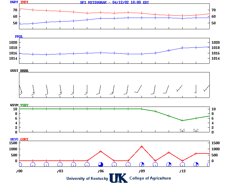
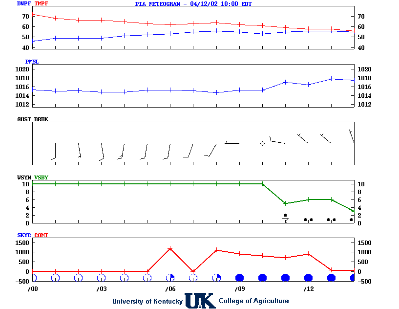
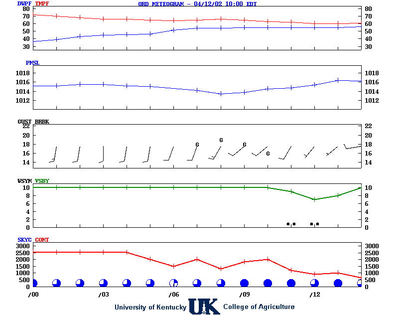
![]() Meteograms : Springfield , Peoria , Quad City , Chicago (O'Hare) , Rockford
Meteograms : Springfield , Peoria , Quad City , Chicago (O'Hare) , Rockford
...WIND ADVISORY REMAINS IN EFFECT FROM 1 PM THIS AFTERNOON TO
1 AM CDT SATURDAY...
.REST OF TODAY...Mostly sunny and windy, warmer with highs in the
upper 70s. South winds 15 to 20 mph with gusts up to 30 mph,
increasing to 20 to 30 mph with gusts up to 45 mph this
afternoon.
.TONIGHT...Showers with thunderstorms likely in the evening, then
partly cloudy with a chance of showers and thunderstorms after
midnight. Windy with lows in the upper 40s. South winds 25 to
30 mph with gusts up to 45 mph, becoming southeast 15 to 20 mph
with gusts up to 35 mph after midnight. Chance of rain near
100 percent.
.SATURDAY...Partly sunny in the morning, then becoming mostly
cloudy. Windy and much cooler with highs in the lower 50s.
Southwest winds 20 to 30 mph. Gusts up to 45 mph in the morning.
.SATURDAY NIGHT...Mostly cloudy. A chance of snow after midnight.
Little or no snow accumulation. Much cooler with lows in the
upper 20s. West winds 10 to 15 mph with gusts up to 30 mph.
Chance of snow 30 percent.
.SUNDAY...Partly sunny in the morning, then clearing. Highs in
the mid 40s. Northwest winds 10 to 15 mph with gusts up to
25 mph.
.SUNDAY NIGHT AND MONDAY...Mostly clear. Lows in the lower 30s.
Highs in the lower 60s.
.MONDAY NIGHT...Mostly clear in the evening, then becoming partly
cloudy. Not as cool with lows in the lower 40s.
.TUESDAY...Mostly sunny. Highs in the upper 60s.
.TUESDAY NIGHT...Mostly cloudy in the evening, then becoming
partly cloudy. Lows in the mid 40s.
.WEDNESDAY...Partly sunny. A chance of rain in the morning, then
rain likely in the afternoon. Cooler with highs in the upper 50s.
Chance of rain 70 percent.
.WEDNESDAY NIGHT...Rain and snow likely in the evening, then a
chance of snow after midnight. Light snow accumulation possible.
Much cooler with lows in the upper 20s. Chance of precipitation
70 percent.
.THURSDAY...Mostly sunny. A chance of snow in the morning. Much
cooler with highs in the upper 30s. Chance of snow 50 percent.
![]() 12-48 Hr Surface, 12-48 Hr ETA 500mb/Sfc, TWC Forecast, Fire Danger, Day 1 Precip, Day 2
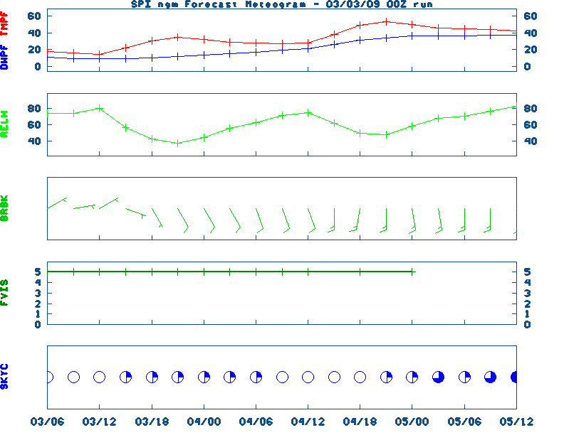
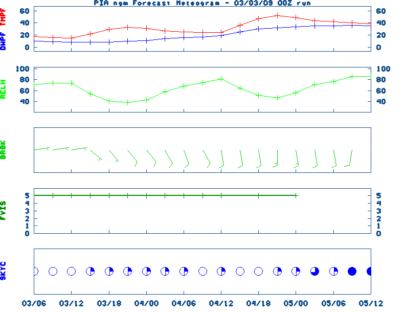
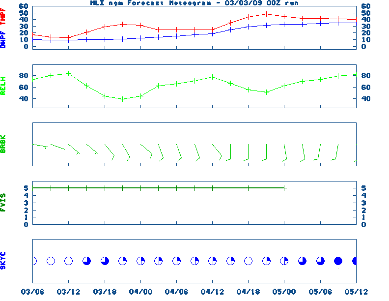
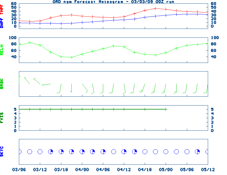
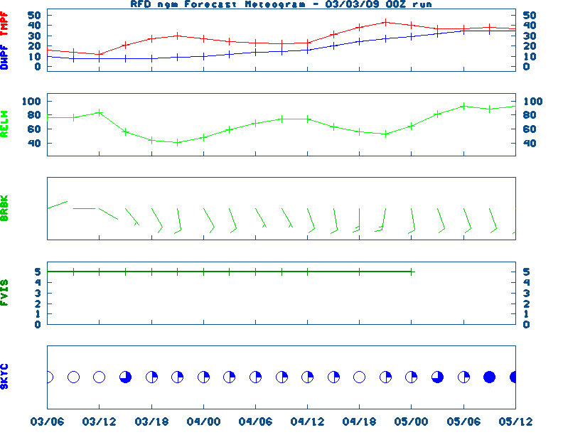
12-48 Hr Surface, 12-48 Hr ETA 500mb/Sfc, TWC Forecast, Fire Danger, Day 1 Precip, Day 2![]() NGM 60 Hr Forecast Meteograms : Springfield , Peoria , Quad City , Chicago (O'Hare) , Rockford ,
NGM 60 Hr Forecast Meteograms : Springfield , Peoria , Quad City , Chicago (O'Hare) , Rockford ,
                 6 TO 10 DAY  8 TO 14 DAY   30 DAY    90 DAY     120 DAY    180 DAY
                                           NOV05   NOV05-JAN06 DEC05-FEB06 FEB06-APR06
                 -----------  -----------  --------  ---------  ---------  ---------
   Temperature:      Below        Below      Above     Normal     Normal     Normal
 Precipitation:      Below        Below     Normal     Normal     Normal     Normal

....  Medium and long range outlooks provided by NCEP/K. Thomas Priddy
MARCH 14TH
HISTORIC WEATHER EVENTS
...1870...
The term "blizzard" was first applied to a storm which produced heavy snow
and high winds in Minnesota and Iowa. (David Ludlum)
...1944...
A single storm brought a record 21.6 inches of snow to Salt Lake City UT.
(The Weather Channel)
...1960...
Northern Georgia was between snowstorms. Gainesville GA received 17 inches
of snow during the month, and reported at least a trace of snow on the
ground 22 days in March. Snow was on roofs in Hartwell GA from the 2nd to
the 29th. (The Weather Channel)
|
|
|