A joint service of the UK Ag Weather Center and the National Weather Service.
608 PM CDT Sun Mar 16 2025

...New AVIATION...

.DISCUSSION...
Issued at 226 PM CDT Sun Mar 16 2025

Rest of the week into early next weekend (Saturday)...

A quiet period is expected through the work week as quasi-zonal
flow & dry thermal profiles persist across the region. As the
trough axis builds eastward & sfc high axis builds across tonight,
gradient winds will relax & the region should efficiently
radiate. Lows will be seasonably cool, some 5-10F below (34-40F).
Can't rule out some light patchy frost in northeast MS, but held
off for now on any mention in HWO. As the sfc high/thermal ridge
builds southeast over the Gulf Coast & low-level warm
advection/return flow picks up, expect moderating trend through
mid-week. Highs will be seasonable to start the week on Monday
(65-72F) before becoming seasonably warm Tuesday to Wednesday,
some 5-10F above (72-80F in this timeframe).

As a 985mb sfc low pressure system ejects northeast of the
central Plains to Mid-West states, pressure gradient will increase
to nearly 6mb. This will support efficient gradient winds & is
supported by blended guidance probs of gusts greater than 40mph
(50-90%). It is a little too far to advertise now but HWO graphics
& potential wind headlines will be needed as we get closer. This
looks to be mostly a dry front & will only bring some light rain
east of I-55 & into the Hwy 45 to I-59 corridors. Another round of
seasonably cool conditions is expected Thursday, highs & lows
some 8-12F below (59-65F for highs & 34-39F for lows Thursday
night). Light frost looks to be a concern again but held off any
mention. This cool pattern will be followed by moderating warmth
into next weekend on Saturday, highs & lows some 3-8F above (highs
74-80F Saturday & lows 44-52F Saturday morning & 48-56F Sunday
morning). A weak shortwave will move in next weekend, bringing
low chances of rain (10-20%) across the Hwy 82 corridor. /DC/
 National Ag. Weather Outlook, International Ag. Weather Summary
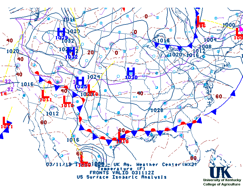
Current Surface Map,
[2nd Source TWC]
Click here for UKAWC Point Agricultural, Lawn & Garden Forecast/Outlook in case of corrupt tables.
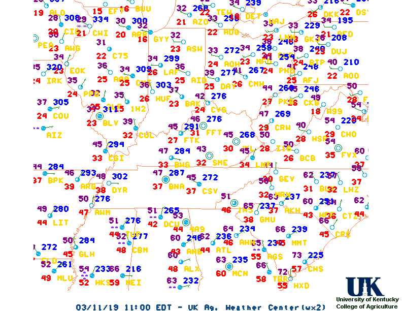
Regional Hourly Observations For County
1000 PM CDT SUN MAR 16 2025
GREENVILLE     CLEAR     47  33  58 W3        30.16R
OLIVE BRANCH   CLEAR     48  18  29 NW5       30.11R
OXFORD         CLEAR     41  27  56 MISG      30.14R
TUNICA         CLEAR     48  25  41 W6        30.15R
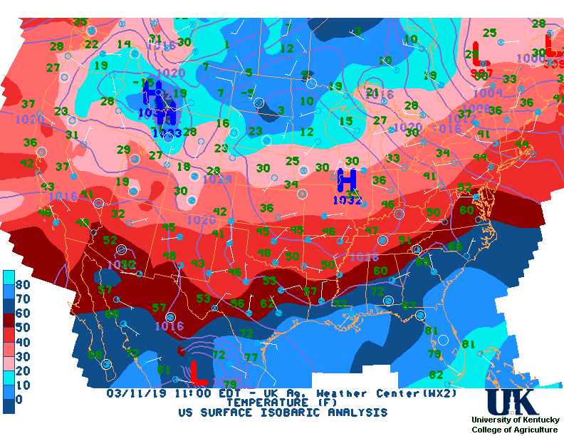
Current Temperatures,
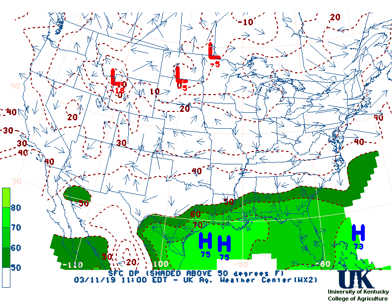
Dewpoint,
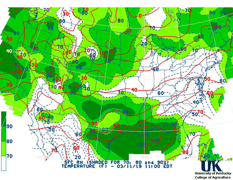
RH,
Wind,
Regional Obs,
Surface 4-Panel
Current Agricultural Weather Conditions in Mississippi
Based on observations at 1000pm CDT, Sunday March 16, 2025
Across Mississippi...temperatures are near 47 degrees north, near 51 degrees central, and near 60 degrees south. Current sky conditions are clear north, clear central, and clear south. In the north, relative humidity is near 47%, and the dew point is near 28 degrees. In the central part of the state, relative humidity is near 42%, and the dew point is near 29 degrees. In the south, relative humidity is near 30%, and the dew point is near 28 degrees. Winds are from the west at 5 mph north, where conditions are favorable for spraying. Winds are calm central, where conditions are favorable for spraying. Winds are from the north at 13 mph south, where conditions are not favorable for spraying due to strong winds. Based on current available observations, the highest temperature is 60 degrees at Biloxi. The lowest temperature is 45 degrees at McComb.
Current NOWCAST not available:
Nowcasts are not issued routinely during fair weather. Only when
precipitation or other significant weather is occuring in this county will these
forecasts be issued. Currently, there is no short term forecast in effect.
US Radar,
All NWS Radars (In near-real time),
Current Livestock Heat Stress Index (LSI),
Current Wind Chill Map
Hazardous Weather Outlook For County
Hazardous report currently not available
NWS Severe Weather Map , Convective Outlook
7-Day Forecast For County, MS
215 PM CDT Sun Mar 16 2025
TONIGHT
Mostly clear. Lows in the mid 30s. Northwest winds
5 to 10 mph.
MONDAY
Sunny. Highs in the mid 60s. Southeast winds around
5 mph, becoming south in the afternoon.
MONDAY NIGHT
Mostly clear in the evening, then becoming partly
cloudy. Not as cool with lows in the upper 40s. South winds 10 to
15 mph with gusts up to 25 mph.
TUESDAY
Sunny, breezy with highs in the lower 70s. South winds
15 to 20 mph with gusts up to 30 mph.
TUESDAY NIGHT
Partly cloudy in the evening, then becoming
mostly cloudy. Breezy with lows in the upper 50s. South winds
15 to 20 mph with gusts up to 35 mph.
WEDNESDAY
Mostly cloudy in the morning, then mostly sunny with
a slight chance of showers in the afternoon. Windy with highs in
the mid 70s. Chance of rain 20 percent.
WEDNESDAY NIGHT
Mostly clear and breezy. Much cooler with lows
in the lower 40s.
THURSDAY
Sunny. Much cooler with highs in the upper 50s.
THURSDAY NIGHT
Mostly clear. Lows in the upper 30s.
FRIDAY
Sunny. Highs in the mid 60s.
FRIDAY NIGHT
Partly cloudy. A chance of showers after
midnight. Not as cool with lows around 50. Chance of rain
30 percent.
SATURDAY
Mostly sunny. A slight chance of showers in the
morning. Highs in the lower 70s. Chance of rain 20 percent.
SATURDAY NIGHT
Mostly clear in the evening, then partly cloudy
with a slight chance of showers after midnight. Lows in the upper
40s. Chance of rain 20 percent.
SUNDAY
Mostly sunny. A chance of showers in the morning, then
a chance of showers with a slight chance of thunderstorms in the
afternoon. Highs in the lower 70s. Chance of rain 40 percent.
12-48 Hr Surface Forecast Maps,
TWC 4-Panel Surface Forecast,
Fire Danger,
Day 1 Precip,
Day 2 Precip,
Days 1-5 Precip,
Severe Weather Pot.-Day 1,
Day 2
Medium & Long Range Outlook For Mississippi
                          MISSISSIPPI
                 ---------------------------------------------
                 6 TO 10 DAY  8 TO 14 DAY   30 DAY    90 DAY
                   MAR 22-26    MAR 24-30    JUN       JUN-AUG
                 -----------  -----------  --------  ---------
   Temperature:     Normal       Normal
 Precipitation:      Above       Normal

....  Medium and long range outlooks provided by NCEP/K. Thomas Priddy
5 Day Rainfall Forecast,
6 to 10 Day ,
8 to 14 Day ,
Text,
30-Day Outook,
90-Day Outook,
120-Day Outlook
Almanac Information
Historical Weather And Climate Facts For Today
MARCH 16TH
HISTORIC WEATHER EVENTS
...1942...
Two tornadoes, 24 minutes apart, struck Baldwin MS resulting in 65 deaths.
(David Ludlum)
...1975...
A single storm brought 119 inches of snow to Crater Lake OR establishing a
state record. (The Weather Channel)
...1986...
A small but rare tornado touched down perilously close to Disneyland in
Anaheim CA. (Storm Data)

Ag Weather Center, Department of Biosystems & Agricultural Engineering, University of Kentucky
|


![[2nd Source TWC]](http://maps.weather.com/images/maps/current/curwx_720x486.jpg)