| ||||||||||||
| ||||||||||||
A joint service of the UK Ag Weather Center and the National Weather Service.
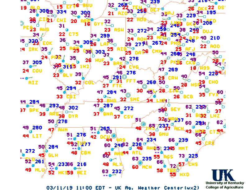
...UPSTATE SOUTH CAROLINA...

CITY           SKY/WX    TMP DP  RH WIND       PRES   REMARKS
ANDERSON       SUNNY     77  49  37 S10       29.93S
LIBERTY        PTSUNNY   74  48  39 S6        29.93S
SPARTANBURG    SUNNY     73  45  35 S3        29.94F
CLEMSON        MOSUNNY   74  51  44 VRB3      29.93F
GREENVILLE     MOSUNNY   75  49  39 S8        29.95F
GREENWOOD      SUNNY     77  47  34 S10       29.94S
GREER          SUNNY     75  46  35 SE6       29.94F
ROCK HILL      MOSUNNY   75  50  41 SW9       29.96R
CHESTER        SUNNY     73  48  40 SE6       29.97R
LAURENS        MOSUNNY   75  50  41 S7        29.94F


...CENTRAL SOUTH CAROLINA...

CITY           SKY/WX    TMP DP  RH WIND       PRES   REMARKS
COLUMBIA APT   MOSUNNY   77  47  34 SE9       29.94R
COLUMBIA OWENS MOSUNNY   78  44  29 S12       29.95R
MCENTIRE ANGB  MOSUNNY   78  44  29 SE10      29.93R
ORANGEBURG     MOSUNNY   78  47  33 S12       29.95R
SUMTER SHAW    MOSUNNY   79  47  32 SE12      29.93R
NEWBERRY       MOSUNNY   77  46  33 E3        29.97S
AIKEN          PTSUNNY   76  47  36 S12       29.96S
BARNWELL       PTSUNNY   77  50  38 SE9       29.95S
MANNING        PTSUNNY   77  46  33 SW9       29.96R
CAMDEN         SUNNY     77  46  33 SE7G13    29.96R
LANCASTER      MOSUNNY   75  48  38 S7G14     29.96R
WINNSBORO      PTSUNNY   77  46  33 S10       29.96R


...EASTERN AND COASTAL SOUTH CAROLINA...

CITY           SKY/WX    TMP DP  RH WIND       PRES   REMARKS
MYRTLE BEACH   LGT RAIN  55  54  96 E10G16    30.04R VSB 1/4
N MYRTLE BCH   PTSUNNY   57  54  89 E13G21    30.02S
CONWAY         SUNNY     64  54  68 SE9       30.01R
MARION         SUNNY     72  55  56 E6        29.98R
HARTSVILLE     SUNNY     73  54  49 E8        29.96R
FLORENCE       SUNNY     78  49  35 SE9       29.96S
DARLINGTON     SUNNY     72  57  59 E10       29.98S
CHARLESTON APT PTSUNNY   71  53  52 SE13      30.00R
MOUNT PLEASANT SUNNY     64  57  77 VRB5      30.00R
WALTERBORO     MOSUNNY   73  50  43 SE10      29.99R
BEAUFORT       MOSUNNY   72  57  59 S10       29.99R
HILTON HEAD    SUNNY     66  57  72 CALM      30.01S


...EASTERN GEORGIA...

CITY           SKY/WX    TMP DP  RH WIND       PRES   REMARKS
AUGUSTA BUSH F MOSUNNY   78  52  40 S10       29.93R
AUGUSTA DANIEL MOSUNNY   77  52  41 S8        29.94R
WASHINGTON     MOSUNNY   76  53  44 S8        29.94S
CLAXTON        PTSUNNY   77  59  53 S8G16     29.94S
SYLVANIA       PTSUNNY   76  54  45 SE8       29.95F
STATESBORO     PTSUNNY   75  53  46 SE7       29.95S
SAVANNAH       CLOUDY    72  53  51 SE15      29.98R


...SOUTHERN NORTH CAROLINA...

CITY           SKY/WX    TMP DP  RH WIND       PRES   REMARKS
CHARLOTTE      PTSUNNY   74  50  42 E10       29.96S
MONROE         SUNNY     74  52  46 VRB5      29.96S
WADESBORO      MOSUNNY   72  51  47 E7        29.98S
ROCKINGHAM     MOSUNNY   67  52  56 E7        29.99S
RUTHERFORDTON  MOSUNNY   70  45  40 S12       29.97S
ASHEVILLE      MOSUNNY   69  44  40 S14       29.97S
Current Agricultural Weather Conditions in South Carolina Based on observations at 600pm EDT, Friday March 14, 2025 Across South Carolina...temperatures are near 75 degrees west, near 77 degrees central, and near 71 degrees east. Current sky conditions are mostly sunny west, mostly sunny central, and partly sunny east. In the west, relative humidity is near 39%, and the dew point is near 49 degrees. In the central part of the state, relative humidity is near 34%, and the dew point is near 47 degrees. In the east, relative humidity is near 52%, and the dew point is near 53 degrees. Winds are from the south at 8 mph west, where conditions are favorable for spraying. Winds are from the southeast at 9 mph central, where conditions are favorable for spraying. Winds are from the southeast at 13 mph east, where conditions are not favorable for spraying due to strong winds. Based on current available observations, the highest temperature is 79 degrees at Sumter Shaw. The lowest temperature is 55 degrees at Myrtle Beach.
Current NOWCAST not available: Nowcasts are not issued routinely during fair weather. Only when precipitation or other significant weather is occuring in this county will these forecasts be issued. Currently, there is no short term forecast in effect. Hazardous Weather Outlook For County Hazardous report currently not available Current FORECAST not available Medium & Long Range Outlook For South Carolina
                           S CAROLINA
                 ---------------------------------------------
                 6 TO 10 DAY  8 TO 14 DAY   30 DAY    90 DAY
                   MAR 20-24    MAR 22-28    JUN       JUN-AUG
                 -----------  -----------  --------  ---------
   Temperature:     Normal        Above
 Precipitation:      Above        Above

....  Medium and long range outlooks provided by NCEP/K. Thomas Priddy
Almanac Information Historical Weather And Climate Facts For Today MARCH 14TH HISTORIC WEATHER EVENTS ...1870... The term "blizzard" was first applied to a storm which produced heavy snow and high winds in Minnesota and Iowa. (David Ludlum) ...1944... A single storm brought a record 21.6 inches of snow to Salt Lake City UT. (The Weather Channel) ...1960... Northern Georgia was between snowstorms. Gainesville GA received 17 inches of snow during the month, and reported at least a trace of snow on the ground 22 days in March. Snow was on roofs in Hartwell GA from the 2nd to the 29th. (The Weather Channel)
Ag Weather Center, Department of Biosystems & Agricultural Engineering, University of Kentucky | ||||||||||||


![[2nd Source TWC]](http://maps.weather.com/images/maps/current/curwx_720x486.jpg)